Showing posts with label Paripatra. Show all posts

Jul 11, 2019

PRATHMIK SCHOOL MA STUDENTS NI NIYMIT HAJRI BABT PAGLA LEVA BABAT SIXAN VIBHAG GANDHINAGAR NO LATEST PARIPATRA DATE:- 04/02/2019.

PRATHMIK SCHOOL MA STUDENTS NI NIYMIT HAJRI BABT PAGLA LEVA BABAT SIXAN VIBHAG GANDHINAGAR NO LATEST PARIPATRA DATE:- 04/02/2019.


NAM KAMI KARVA ROJKAM NO NAMOONO PDF COPY DOWNLOAD KARO.
 

PRATHMIK SCHOOL MA STUDENTS NI NIYMIT HAJRI BABT PAGLA LEVA BABAT SIXAN VIBHAG GANDHINAGAR NO LATEST PARIPATRA DATE:- 04/02/2019.

Niche apel blue link par click Karo


Jul 6, 2019

Shala no samay 11 thi 5 karva babate paripatra -6/07/2019 mahesana see

Shala no samay 11 thi 5 karva babate paripatra -6/07/2019 mahesana see

Somvar thi 8/07/2019 mahesana Jilla ni tamam primary school ma shala no samay 11 thi 5 no rehse 

Garmi na Karne guruvar thi shala no samay savar no rakhavama avyo hato. 


Jul 3, 2019

Shala no samay savar no karva babate paripatra mehasana -3/07/2019

Shala no samay savar no karva babate paripatra mehasana -3/07/2019

Mahesana Jillama varsad thayel na hovathi shala ma balkone nuskeli padti hovathi savar no samay karva .


May 4, 2019

Dhoran and vishay vehchani babate niyamak Shri no paripatra see here

Dhoran and vishay vehchani babate niyamak Shri no paripatra see here


CLICK HERE FOR VIEW AND DOWNLOAD


Aaj ka gyan
In late September 2010, a wide band of disturbed weather and low pressure, associated with the monsoon trough and remnant tropical moisture from Tropical Storm Matthew, meandered over the northwestern Caribbean Sea.[3] With a broad upper ridge anchored along the Yucatáncoast, diffluence aloft in the vicinity of the disturbance provided focus for the development of scattered convection.[4] The National Hurricane Center (NHC) noted an environment supportive of tropical development, and by September 27, a broad surface low formed amid the convection.[5]The next day, surface pressures steadily dropped as sustained winds around the low proximated tropical storm force.[6]Throughout the development process, moderate westerly wind shear over the region caused the disturbance to exhibit a rather asymmetric structure;[1] it developed an elongated low-pressure center by September 28, well to the northwest of its strongest wind field.[7] Despite the asymmetry, the NHC initiated advisories on a tropical depressionaround 15:00 UTC that day, after surface and satellite observations revealed a sufficiently defined circulation center west of the deep convection.[8] Post-season reassessments, however, indicated that a tropical storm had, in fact, formed three hours earlier, about 75 miles (120 km) south of Cuba's Isle of Youth, which operationally was not named Nicole until a day later


Mar 11, 2019

Salang nokri ganava babate rajya Sarkar no 8/03/2019 no paripatra see here

Salang nokri ganava babate rajya Sarkar no 8/03/2019 no paripatra see here

Click here to view


PayScale was developed to help people obtain accurate real-time information on job market compensation. The service works via the Internet by enabling individual employees to submit their job profile and salary data, which is then compared to others. The company claims that it is able to use the volume of information statistically to determine accurate real-time salary information.[6]
The company generates revenue by selling aggregate data and web services to employers, to aid in determining correct market rates for hiring, benchmarking and budgeting, and by targeted advertising to employees that visit its web site.
The company has published rankings of U.S. universities based on "return on investment," or the purported difference between student expenditures for a university degree and the money they earn from it.[7] These rankings are dramatically different from better-known rankings published by U.S. News and World ReportForbesThe Economist, and other mainstream publications (for instance, PayScale places Yale University 93rd among American universities and Georgetown University 132nd). The Chronicle of Higher Education has criticized PayScale for using misleading sample sizes and for omitting all alumni of universities who go on to grad school from its count

Mar 5, 2019

6/3/2019 na roj teleconference ma mukhy sixak ane STD 2-3 na sixake hajar rehva babate paripatra see here

6/3/2019 na roj teleconference ma mukhy sixak ane STD 2-3 na sixake hajar rehva babate paripatra see here


The rotational period and seasonal cycles of Mars are likewise similar to those of Earth, as is the tilt that produces the seasons. Mars is the site of Olympus Mons, the largest volcanoand second-highest known mountain in the Solar System, and of Valles Marineris, one of the largest canyons in the Solar System. The smooth Borealis basin in the northern hemisphere covers 40% of the planet and may be a giant impact feature.[18][19] Mars has two moonsPhobos and Deimos, which are small and irregularly shaped. These may be captured asteroids,[20][21] similar to 5261 Eureka, a Mars trojan.
There are ongoing investigations assessing the past habitability potential of Mars, as well as the possibility of extant life. Future astrobiology missions are planned, including the Mars 2020 and ExoMarsrovers.[22][23][24][25] Liquid water cannot exist on the surface of Mars due to low atmospheric pressure, which is less than 1% of the Earth's,[26] except at the lowest elevations for short periods.[27][28] The two polar ice caps appear to be made largely of water.[29][30] The volume of water ice in the south polar ice cap, if melted, would be sufficient to cover the entire planetary surface to a depth of 11 meters (36 ft).[31] In November 2016, NASA reported finding a large amount of underground ice in the Utopia Planitia region of Mars. The volume of water detected has been estimated to be equivalent to the volume of water in Lake Superior.[32][33][34]
Mars can easily be seen from Earth with the naked eye, as can its reddish coloring. Its apparent magnitude reaches −2.94,[11] which is surpassed only by JupiterVenus, the Moon, and the Sun. Optical ground-based telescopes are typically limited to resolving features about 300 kilometers (190 mi) across when Earth and Mars are closest because of Earth's atmosphere.[35]

Feb 15, 2019

Vadh ghat camp yojava babate paripatra see here

Vadh ghat camp yojava babate paripatra see here

Click here to view for mahesana

Banaskatha


Kachh -bhuj


Mission highlights included the initial 90-sol mission, finding extramartian meteorites such as Heat Shield Rock (Meridiani Planum meteorite), and over two years of exploring and studying Victoria crater. The rover survived less severe dust storms and in 2011 reached Endeavour crater, which has been described as a "second landing site".[13] The Opportunity mission is considered one of NASA's most successful ventures.[14]
Due to the 2018 dust storms on Mars, Opportunity ceased communications on June 10 and entered hibernation on June 12, 2018. It was hoped it would reboot once the weather cleared,[15] but it did not, suggesting either a catastrophic failure or that a layer of dust has covered its solar panels. NASA hoped to reestablish contact with the rover, citing a windy period that could potentially clean off the solar panels of the rover.[16] On February 13, 2019, NASA officials declared that the Opportunity mission was complete, after the spacecraft failed to respond to repeated signals sent since August 2018.


Feb 14, 2019

Badli babte aaj no paripatra 14/02/2019 see here

Badli babte aaj no paripatra 14/02/2019 see here

Mission highlights included the initial 90 sol mission, finding extramartian meteorites such as Heat Shield Rock (Meridiani Planum meteorite), and over two years exploring and studying Victoria crater. The rover survived less severe dust-storms and in 2011 reached Endeavour crater, which has been described as a "second landing site".[10]
Due to the 2018 dust storms on Mars, Opportunity ceased communications on June 10 and entered hibernation on June 12, 2018. It was hoped it would reboot once the atmosphere cleared,[11] but it did not, suggesting either a catastrophic failure or that a layer of dust has covered its solar panels. NASA hoped to reestablish contact with the rover, citing a windy period that could potentially clean off the solar panels of the rover.[12] On February 13, 2019, NASA officials declared that the Opportunity mission was complete, after the spacecraft failed to respond to repeated signals sent since August 2018.[13]


Feb 8, 2019

Aaj no niyamak no paripatra jillafer badali , vadh ghat , JILLA vibhajan camp , Navi Bharti na order for primary school

Aaj no niyamak no paripatra jillafer badali , vadh ghat , JILLA vibhajan camp , Navi Bharti na order for primary school

Mihdhar was born in Saudi Arabia and fought with the Bosnian mujahideen during the Bosnian War of the 1990s. In early 1999, he traveled to Afghanistan where, as an experienced and respected jihadist, he was selected by Osama bin Laden to participate in the attacks. Mihdhar arrived in California with fellow hijacker Nawaf al-Hazmi in January 2000, after traveling to Malaysia for the Kuala Lumpur al-Qaeda Summit. At this point, the CIA was aware of Mihdhar, and he was photographed in Malaysia with another al-Qaeda member who was involved in the USS Cole bombing. The CIA did not inform the FBIwhen it learned that Mihdhar and Hazmi had entered the United States, and Mihdhar was not placed on any watchlists until late August 2001.
Upon arriving in San Diego County, California, Mihdhar and Hazmi were to train as pilots, but spoke English poorly and did not do well with flight lessons. In June 2000, Mihdhar left the United States for Yemen, leaving Hazmi behind in San Diego. Mihdhar spent some time in Afghanistan in early 2001 and returned to the United States in early July 2001. He stayed in New Jersey in July and August, before arriving in the Washington, D.C. area at the beginning of September.
On the morning of September 11, 2001, Mihdhar boarded American Airlines Flight 77, which was hijacked approximately 30 minutes after take off. The plane was deliberately crashed into the Pentagon, killing all 64 people aboard the flight, along with 125 on the ground


Feb 6, 2019

STD 3-5 ganit talim second semester babate paripatra see here

STD 3-5 ganit talim second semester babate paripatra see here

Click here to view details


Aaj ka gyan

On April 16, 1827, a team of three surveyors were commissioned to determine a routing for a new highway leading from Hopkinton, a town in northeastern St. Lawrence County, to Lake Champlain.[9] The task took 26 days, after which it was determined that the highway would meet Lake Champlain at Fort Kent.[10] An act authorizing the construction of the highway was passed by the New York State Legislature on April 18, 1829. A total of approximately $38,500[11] (equivalent to $905,833 in 2019)[12] was devoted to the project by the state of New York through the same act.[11]
The 75-mile (121 km) highway opened in 1833 as a toll road named the Port Kent and Hopkinton Turnpike.[9] The turnpike had only one toll gate, located near the center of the route. Two years later, the turnpike commissioners petitioned to the state of New York, asking for permission to replace the single gate with two gates at opposite ends of the turnpike that would collect half of the toll amount. The commissioners believed that the change in the toll gate locations would result in higher revenue, allowing them to continue maintaining the highway.[13] The change was approved;[14][15] however, the toll road was dissolved anyway three years later on March 30, 1838. At that time, maintenance of the Port Kent–Hopkinton highway was transferred to the towns it ran through.[16]
The Theodore Roosevelt International Highway, a transcontinental auto trailextending from Portland, Oregon, to Portland, Maine, was established in 1919.[17] In eastern New York, the highway went through KeesevilleAusable Chasm, and Fort Kent along what used to be the Port Kent and Hopkinton Turnpike before entering Vermontby way of the Burlington–Port Kent Ferry across Lake Champlain.[18]
The state of New York assumed maintenance of most of the Ausable Chasm–Port Kent roadway at some point after 1920.[19] In the 1930 renumbering of state highways in New York, the entirety of the highway from Ausable Chasm to the Port Kent ferry landing was designated as NY 373,[1] despite the fact that the small portion of the route east of Lake Street in Port Kent was not maintained by the state at the time.[20] On April 1, 1985, ownership and maintenance of NY 373 east of Lake Street was transferred from the town of Chesterfield to the state of New York as part of a highway maintenance swap between the state and Essex County

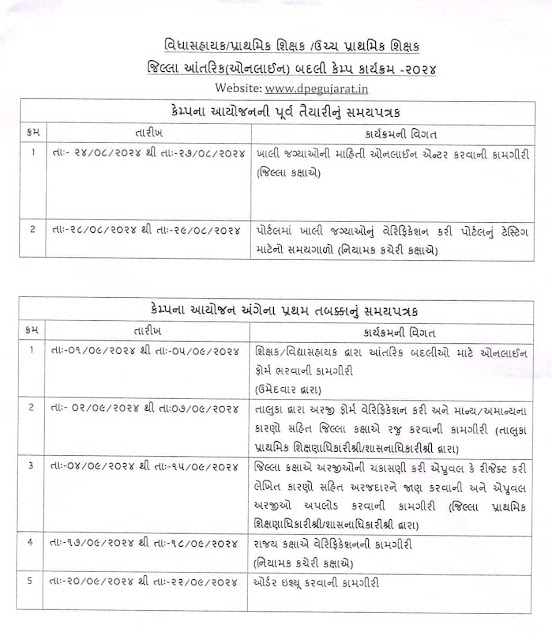
ગુજરાત પ્રાથમિક શિક્ષક બદલી કેમ્પ 2024

આ લિંક પરથી તમે બદલી ઓર્ડર ડાઉનલોડ કરી શકશો.. બદલી હુકમ અહીથી ડાઉનલોડ કરો ઓનલાઇન બદલી હુકમ આજથી બાબતનો  જિઆર અહીથી વાંચો 💥 *બદલી ઓર્ડર ડાઉન...